SOURCE: NDTV
Bhutan on Friday denied reports that China has constructed a village more than 2 kilometres inside Bhutanese territory near the contested Doklam plateau, despite clear satellite imagery and detailed map locations to the contrary.
Maps bearing the official seal of the Bhutan government, accessed by NDTV, also indicate that this new Chinese settlement lies well within Bhutan’s present claim lines. Reacting to NDTV’s report that highlighted what appears to be a clear Chinese incursion, Major General Vetsop Namgyel, Bhutan’s Ambassador to India, said, “There is no Chinese village inside Bhutan.”
On whether Bhutan and China had reached any understanding on realigning the border in the contested area, the Ambassador said he “does not comment on border matters.” He did, however, confirm that Bhutan and China were involved in border talks, a process slowed down by the coronavirus pandemic.
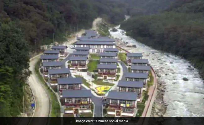
On Thursday, Shen Shiwei, a senior producer with CGTN, China’s state-sponsored media, showcased several images of the village which features a road and chalets by the side of a river and tweeted, “Now, we have permanent residents living in the newly established Pangda village. It’s along the valley, 35 km south to Yadong country. Here is a map to show the location.”
International observers, including Nathan Ruser, a satellite imagery analyst with the Australian Strategic Policy Institute, responded to Shen’s tweets by highlighting that the location of the Chinese village indicated a clear breach of Bhutan’s sovereignty.
“Here’s a CGTN news producer openly admitting that China has occupied and now populated part of a sovereign country,” tweeted Mr Ruser. “This Pangda village has been constructed (as shown by the included map) 2.5 km beyond Bhutan’s international border. China now baselessly claims about 12 per cent of Bhutan,” Mr Ruser said.
Responding to this morning’s denial by Bhutan, Mr Ruser tweeted: “Weird statement considering there’s satellite imagery and extensive photos from the ground of this village inside Bhutan, 9 kilometres from the Doklam face-off site. Seems like a blatant untruth to me.”
Other international observers, including Detresfa, who works extensively on Chinese developments across the Sino-Indian border region, have independently tweeted the exact map location of Pangda village. Satellite imagery of the location precisely matches images of the now-completed village that have been shared on social media in China.
The new Chinese village lies in an area of immense sensitivity to India.
In 2017, the armies of India and China had faced off at a site on the Doklam plateau, just 9 km to the west of this settlement. Beijing insists that Doklam is Chinese territory, while India backs Bhutan’s claim over the area. India has historically been a net-security provider of Bhutan with both countries having agreements to closely cooperate with each other on issues of national importance.
On June 30, 2017, at the height of the standoff between Indian and Chinese forces, New Delhi accused Beijing of violating a 2012 agreement by unilaterally altering the status quo of the tri-junction boundary in the region. New Delhi believes this tri-junction between India, China and Bhutan lies north of the 2017 faceoff site at Doka La – on the western edge of the Doklam plateau – while Beijing believes it lies well to the south at Mount Gipmochi as per an 1890 treaty.
For India, any Chinese move to encroach further south in the Doklam plateau region would place it perilously close to the narrow and potentially vulnerable Siliguri corridor, the narrow sliver of land which links India’s north-eastern states with the rest of the country.
It is for this reason that any realignment of the boundary between Bhutan and China within the broader Doklam area would sound alarm bells in New Delhi. And yet, the Bhutanese denial of any Chinese encroachment on their territory is an indicator that this is precisely what may be happening.
In a series of tweets this morning, Tenzing Lamsang, editor of The Bhutanese newspaper, pointed out, “Bhutan and China recognise the 269 sqkm in the west and 495 sqkm in north-central Bhutan as [being] disputed and so while there are maximalist claim lines from both sides, there is no mutually accepted international border there yet.”
India would want to know whether dialogue between Bhutan and China has meant that the tiny village of Pangda, widely showcased by Chinese state media, is now part of territory that till recently belonged to Bhutan – but may now be Chinese.