
SOURCE: PTI
In a novel way to protest against Nepal’s claim of areas along Indian border, an organisation on Thursday came out with an envelope with the copy of a postage stamp, purportedly released by the Himalayan nation in 1954 printed on it, showing that the areas under dispute actually belong to India. The Bharat Raksha Manch, stated to be a non-political organisation formed in 2010 with an aim to tackle the menace of infiltration, which released the envelope here, claimed that it has sent the cover to Prime Minister of Nepal, KP Sharma Oli, and 59 members of the Nepalese National Assembly.
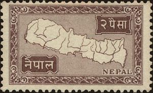
Since 1954, Nepal has issued 29 postage stamps in which the nation’s map has always been depicted as claimed by India, said Anil Dhir, National Secretary of the Manch and a noted philatelist.
“They have never shown Kalapani as their territory or a disputed area. Those areas were never included in official maps of the (Nepal) government and the maps in school atlases,” Dhir, who has four books on philately to his credit, said.
The envelope with the map stamp of 1954 was brought out as a mark of protest and it was also sent to the Nepalese High Commissioner to India, the president of the Philatelic Society of Nepal and others in that country, he said.
The ties between the two countries came under strain after Defence Minister Rajnath Singh inaugurated a 80km strategically crucial road connecting the Lipulekh pass with Dharchula in Uttarakhand on May 8.
Nepal reacted sharply to the inauguration of the road claiming that it passed through Nepalese territory. India rejected the claim asserting that the road lies completely within its territory.
The Nepal government on May 20 released a revised political and administrative map showing Limpiyadhura, Lipulekh and Kalapani under its territory, angering India which asked Kathmandu not to resort to any “artificial enlargement” of its territorial claim and refrain from such “unjustified cartographic assertion”.