
SOURCE: HT
The Centre’s decision to ask television channels to include weather reports and forecasts for Pakistan-occupied Kashmir and the Northern Areas signals a significant shift in India’s strategy on Imran Khan’s Pakistan, people familiar with the development told Hindustan Times on Friday.
The move was conceived by National Security Adviser Ajit Doval “some time back”, a top government official said. The formal proposal, crafted a little over three months back, went out from Deputy National Security Adviser (Strategic Affairs) Rajinder Khanna’s office on 3 February to the secretaries of foreign and home ministries apart from chiefs of India’s two lead intelligence agencies: Intelligence Bureau and the Research and Analysis Wing.
Their formal approvals came last week.
At one of the early discussions that were held to finetune the proposal, the official recalled how Doval had spoken of the multiple messages that this one move would send.
The central point, the official said, is that “this is my area and I am asserting my sovereignty by taking all the steps”.
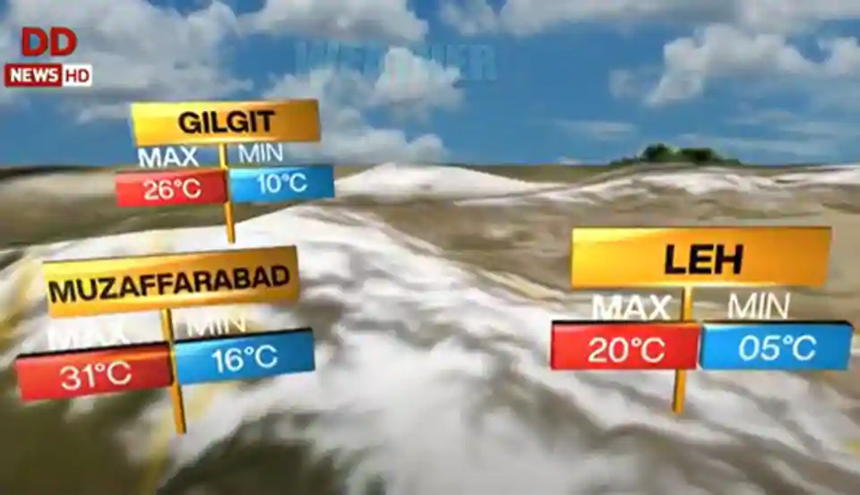
This week, the government told public broadcaster Doordarshan to include weather forecasts of Mirpur and Muzaffarabad in Pakistan-occupied Kashmir and Gilgit in the Northern Areas that are described by Pakistan as “Gilgit Baltistan”. Some private news channels have already told the government that they will also make changes to their weather bulletins.
Doordarshan was also told to use weather maps that include the entire territory of Jammu and Kashmir that would serve as a daily, and public reiteration of India’s stand.
A second senior government official said the move marked a shift in India’s approach that had been perceived to be hesitant to go all out to hammer the message to Pakistan, its allies and the world that Islamabad was in illegal occupation of over 86,000 square km of Jammu and Kashmir.
This changes.
For one, the assertion of sovereignty becomes particularly important because of the China-Pakistan Economic Corridor that passes through the Northern Areas or, the expansive Gilgit-Baltistan region that is almost twice the size of Kerala.
When China floated the Belt and Road Initiative a few years ago, it had expected India to be part of the project though it passes through the Northern Areas under Pakistani control. When India protested, Beijing told New Delhi to still join in because this would not affect the status of Kashmir as a dispute between the two countries.
“The daily weather map reinforces India’s message on the entire territory of J&K, every day,” the official said.
The daily weather forecast, and the map of India on the television screens, also underlines India’s strong views on the occupied territory but also the fact that Pakistan was making material changes to the region and exploiting the population of this region.
In many ways, the official said, the map of India on the television screens also spotlights the plight of the people living in these areas whose rights are violated by Islamabad on a daily basis.
There is another constituency that India hopes to message: the political establishment in the United Kingdom to ask them to not take sides.
A large proportion of the Pakistani expatriate population in the United Kingdom is from Mirpur who have close links with Labour Party leaders such as Jeremy Corbyn who had gone to the extent of passing a resolution to seek international intervention after India scrapped Jammu and Kashmir’s special status.
https://defencenewsofindia.com/nsa-ajit-doval-packs-in-3-blunt-messages-to-pak-in-daily-pok-weather-forecast/