
SOURCE: INDIA TODAY
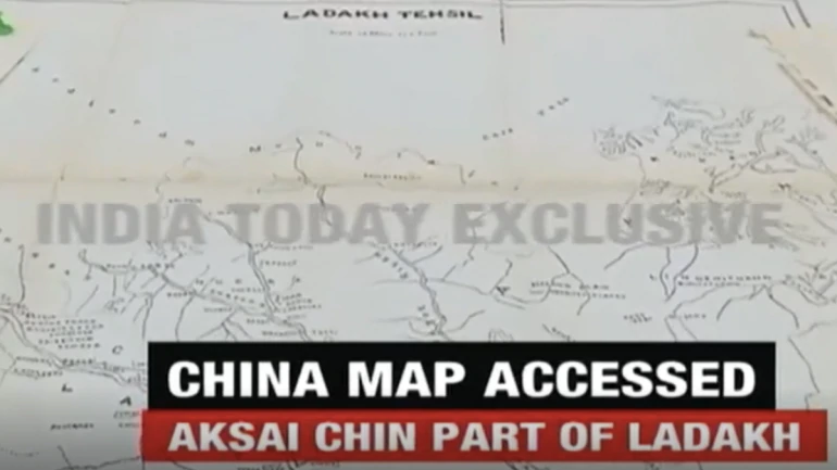
Chinese maps from the late 19th and early 20th century show Aksai Chin — a region under Chinese occupation since the 1962 war — as part of the Ladakh region, a finding that supports India’s position on the subject. A 1919 map of Tibet indicates that the Aksai Chin area “is as per the Indian perception”, said Lt. Gen. (Retd.) Gurmit Singh, a former Kashmir Corps Commander.
The other, older maps — also seen by India Today TV — are from 1893 and 1909. (Click on the playable image above to see the video report.) The findings come at time of rising border and diplomatic tensions between the two Asian giants. In recent weeks, Indian and Chinese soldiers have skirmished in eastern Ladakh and northern Sikkim. As well, Beijing has protested congratulatory messages sent by BJP MPs to Taiwan’s newly-elected pro-independence leader.
U.S. President Donald Trump waded into the controversy this week by saying Prime Minister Narendra Modi was “not in a good mood about what’s going on with China”. This, a day after offering to mediate what he called a “raging border dispute”.
Yet sources say Modi and Trump last spoke in early April and have held no recent discussions about the situation at the China border.
Meanwhile, the government is under pressure from political rivals to reveal more about the ongoing dispute to the public. Rahul Gandhi said its silence was “fuelling massive speculation and uncertainty at a time of crisis,” and asked it to “come clean and tell India exactly what’s happening.”
Prashant Kishor, a former campaign advisor to PM Modi who was recently sacked by a key NDA ally, said, “We can forget all our worries as India seems to have truly arrived at the global stage. We now have the President of the United States informing the world about the mood of our Prime Minister!”
https://defencenewsofindia.com/old-chinese-maps-show-aksai-chin-as-part-of-ladakh/