SOURCE: THE PRINT
One of the main reasons that seem to have upset China is the creation of border infrastructure on the Indian side of the Line of Actual Control or LAC. When roads, passes, bridges and high landing grounds come up in inhospitable terrains, they do cause discomfort to the adversary. And when these become operational, the threat gets a little too real for those manning the posts on the other side of the border.
Daulat Beg Oldi, or the DBO, and the Fukche trial landing success was a great morale booster for my entire squadron and an encouragement for me. There was a mood of ‘ye dil mange more’. Therefore, Nyoma was identified in 2009 to be the next destination because of its strategic importance.
But before we move on to discuss the actual planning and trial landing, let me narrate a very interesting episode.
Why we need information security
In January 2009, military journal Jane’s Intelligence Review published an article titled ‘Mountain Tensions: India strengthens air bases near China’ by Brian Cloughley, a South Asia analyst and former defence attaché to Pakistan. The author had evaluated India’s increasing aerial capability in the Northern sector and the consequence this will have on its Northern neighbour.
In his article, Cloughley had deliberated upon the trial landings at the DBO and Fukche that had taken place in 2008. He had even predicted the likely plan of the construction of an airfield at Nyoma with the help of satellite images and an in-depth study of the advance landing ground. The actual trial landing was executed in September 2009, almost nine months after Cloughley’s article was published in January the same year when the whole project was only at the planning stage.
It is media reports like these that should force us to review our information security apparatus on a continuous basis. We live in a world where satellites are beaming images of the area that may interest our adversaries. Space security is the answer to it and India has taken a big step in this direction by conducting its first anti-satellite (ASAT) missile test, Mission Shakti.
Why Nyoma becomes strategic
One look at the geographical map of the Northern region will show you that China can march forward in our territory only through two axes because these are negotiable only through valleys. The high ranges deny easy access.
The first axis is one from Daulat Beg-Oldie Shyok-Darbuk-Nubra. This is a difficult route for movement of troops and vehicles because near Saser Kangdi, the route becomes treacherous and difficult to negotiate.
The other axis involves crossing the Indus river, following the valley to Nyoma, and then to Leh. This is a much easier route because it goes through a valley. So, to deny the Chinese easy access to Leh (the most important town in Ladakh) or increase their difficulty of marching over to Leh, it was important to have an airfield on this route.
Nyoma was the only place with desired flat land availability where a runway could be constructed. Nyoma is a village and the headquarter of the eponymous subdivision and block in the Leh district of Ladakh. It is located in the Leh tehsil, on the bank of Indus River. The town lies on the Leh-Loma-Hanle road. Nyoma is located 41 km southeast of Chumathang. It is 23 km from Mahe village and roughly the same distance from the Chinese border.
Feasibility first
My Squadron took up the challenge of checking the feasibility of the construction of an airfield in this area. A paradrop of troops by An-32 aircraft was attempted first and the results were encouraging. The next step was to check the feasibility of constructing a runway. Ground recces did bring up the challenges the site would throw up. The flat area around Nyoma, which is next to a river bed was just about sufficient for the construction of an airfield. Since the site is next to a river, the entire area was sandy and ground compaction — as executed in DBO or Fukche — was not possible. A hillock that was right at the beginning of this flat ground was envisaged to be an obstruction for landing. A more in-depth study was undertaken to find solutions and a decision was arrived at, that a 6,500-7,000 feet runway can be constructed.
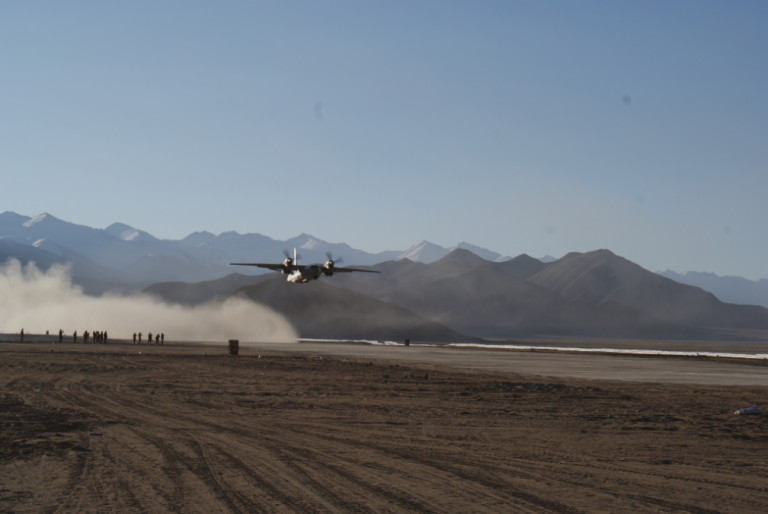
The next challenge was ground compaction, so that it could take the weight of a landing aircraft. A cement-like compound (RB-18) was used along with locally available sand to harden the surface. The Army’s back-breaking hard work followed. However, availability of water, which was required in plenty due to the use of the cement-like compound, increased the complexities of the task and a runway, though unpaved (kaccha), was ready by mid-September 2009. A 7,000-feet runway at an elevation of 13,500 feet was ready for An-32 operations.
The circuit pattern
My task of formulating a circuit pattern for landing commenced simultaneously. Likely emergencies were practiced. In fact, the circuit pattern was flown prior to runway readiness and we were ready for another historic feat. Although the runway elevation was almost 3,000 feet less than DBO, all other flying challenges were the same — high-altitude operations and high mountains surrounding the airfield, leaving less manoeuvring space for aircraft. In addition to this, on finals, our An-32 initially had to be maintained left-on-centre line of runway to clear the hill, which was too close to approach path once you crossed the hill abeam. Then, for the final alignment with the runway, one had to quickly turn to right (and time available for it was less) to execute a a safe landing. So, the degree of difficulty was high for this action.
Meanwhile, I was transferred to Air Headquarters from Chandigarh with effect from August 2009. So, I started training my Squadron QFI (Qualified Flying Instructor) for the mission, to ensure that even if I move out, the trial landing can still be accomplished. For the Indian Air Force (IAF), the task was of immense importance, hence, the thinking was: the ‘show must go on’ with or without me. However, it was not to be so — my new posting was cancelled and the trial landing was advanced to 18 September 2009.
This time, the next air officer commanding-in-chief (AOC-in-C) had assumed the charge and he was on board for the mission, not in the cockpit as a crew but as a passenger. The Army commander who played an important role in supervision during the construction of the airfield was also on board. I still remember a query by one of my junior officers — why do senior officers travel as passengers in such difficult missions, doesn’t this add to pressure on the crew to perform? Is it that the missions won’t be successful if they are not on board? His question was logical because, for all my three-trial landings in these strategically important areas closer to the border, one Air Marshal was always on board. I had to give him a lesson on leadership to explain the reasons, the major one was about ‘leading from the front’. I had said this without much conviction because some seven years ago — in 2002 — I had failed in an important mission at Kargil with an Air Marshal in the cockpit as the co-pilot.
The first flight
We took off from Chandigarh and followed the formulated circuit pattern, almost hugging the hills. The approach parameters were established as desired. On short finals, the aircraft was aligned slightly to the left-of-centre line of the runway. However, after crossing the hill abeam on short finals, the aircraft was brought back on to the centre line prior to landing.
Landing was smooth and well executed in spite of a long float due to higher TAS (true airspeed). On ground, the engines were kept running. The AOC-in-C and GoC-in-C congratulated all the Engineering regiment officers and men for readying the airfield in the shortest time. After a well-deserved cup of tea, we were ready for our departure. Takeoff was uneventful, but not without few bumps and lots of dust being raised behind the aircraft.
Few more landings were executed for pilot clearances. Future plan, as per media reports, suggests that relaying of a bitumen runway is sanctioned and a paved runway will be ready shortly. If a runway is constructed, all types of aircraft, including fighters, will be able to operate from this airfield.
In 17 months, three airfields of immense strategic importance were made operational after nearly 43 years. All three had common features — elevation above 13,000 feet, all unpaved runways (kuccha airstrips), all located very close to LAC, and all next to high mountain ranges and in inaccessible areas. The most important feature that binds all three is their strategic importance. I, along with my team, achieved what was not attempted for nearly four decades. One definitely feels proud that what was proposed, planned, conceived and executed at a tactical level is proving to be a strategic advantage for the nation in this time of crisis.


