SOURCE: THE WEEK
India and Nepal share a very close relationship, which has withstood the shifting sands of time. Due to the symbiotic nature of the relationship that is based on economic and strategic interests of the two countries, this relationship is very crucial for both. It is in the interests of both the nations to consolidate this friendship and progress ahead in a fruitful manner.
However, keeping in mind the current regional scenario and internal political environment accruing in Nepal, there has been a surreptitious attempt by some vested political interests to derail this long and traditional association and friendship between the close neighbours. Not all the blame can be attributed to external factors or a third country, because it is also in the interests of the current ruling government of Nepal to strike a strident note on anything that can be associated with territorial integrity and sovereignty.
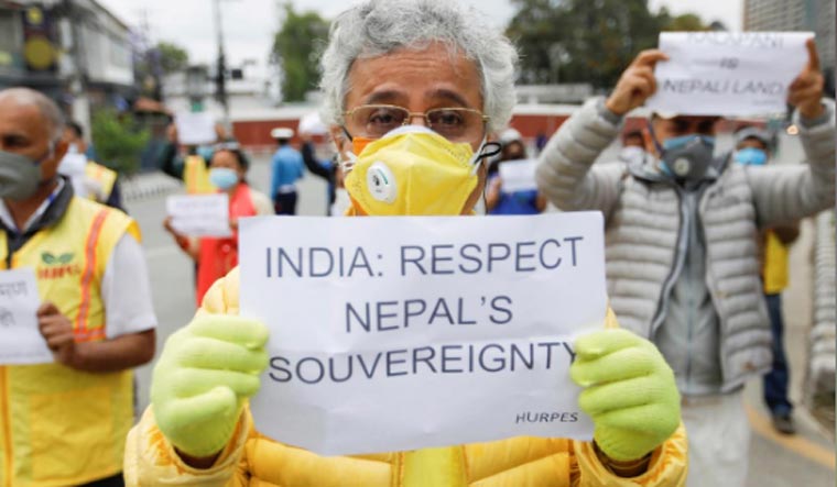
However, Nepal’s change of tenor in recent bilateral issues—starting from the Terai blockade to the recent assertions over Kalapani—is a manifestation of its aggressive diplomacy, which indicates that it is willing to sacrifice the close bilateral relationship at the altar of national politics.
In this sequence of events, Nepal’s vehement protests and redrawing of maps subsequent to the inauguration of the 80km strategic road connecting Lipulekh to Dharchula are a mere ploy by Nepal’s ruling dispensation to further bolster its nationalist image and divert attention of mis-governance, thereby giving them a fresh lease of life. Moreover, the strategic nature of the road and its implications on movement of troops will definitely be a cause of concern for another country sharing a tumultuous relation with India. It is no secret that this emerging global power is unhappy with any infrastructure development along the borders and has often used direct or indirect methods to pressurise smaller nations to toe its line.
No third country has a locus standi on the issue because of various historical facts. The dispute of Lipulekh is a boundary dispute between Nepal and India. The treaty of Sagauli, signed on March 4, 1816, between the British and Gurkhas after the culmination of the Anglo-Gurkha War of 1812-1815 forms the basis of the India-Nepal boundary. The boundary line between the two countries was surveyed and demarcated from 1816 to 1860, from 1882 to 1885, in 1906 and, finally, from 1940 to 1941. In this process, carried out in nine different sectors, 913 boundary pillars were erected.
However, the area of Dharchula district was not addressed, leading to an ambiguity on the origin of the Kali river. Post-independence, the Treaty of Peace and Friendship between the government of India and the government of Nepal was signed on July 31, 1950. There was no mention of any boundary agreement between the two countries.
It was only in 1981 when Nepal raised the issue of encroachment of its land by Indian citizens that an India-Nepal Joint Tech Level Boundary Committee was formed in November 1981. Since then, various minor issues have been resolved, additional pillars erected and strip maps of the resolved areas redrawn.
But the Joint Committee has not been able to arrive at a consensus with regard to differing perceptions of the origin of Kali river in the west and in a small area of Satsu on the banks of Ghandak river in Terai Region. India believes that Kali river originates at Kalapani. Hereafter, the boundary follows the watershed to south of Kalapani, moving further towards east and joining the main Zanskar range at Pt 5570 near Tinker Lipu Pass, which is the Indian perception of the Tri-junction.
Nepal does not believe Kalapani to be the origin of Kali river and its stand has been vacillating between the two tributaries of Kali river—Lipu Gad and Kuthi-Yangti river—which is evident from the fact that in 1819 Nepal’s maps showed Kuthi Yangti river as Kali river originating from Lampiya Dhura. In 1851, Nepal’s maps showed Kali river as Kuthi Yangti river and stream originating from Lipulekh was left unmarked and in 1975, Nepal’s maps showed Lipu Gad as Kali river. However, in 1892, Nepal’s maps showed India Nepal-boundary in Kalapani sector along the watershed between Lipu Gad and Tinkar, which conforms to the current alignment of India-Nepal boundary.
Similarly, in 1929, when the Survey of India submitted ‘8 Mile Map’ of Nepal sharing boundary along the watershed of Tinkar and Kali river, as per Indian claims, the Nepal government raised no objection to it. Thus objecting at this stage and creating an issue out of it belies any logic.
In contrast to Nepal’s vacillating stance, India has always maintained a nuanced narrative based on well-documented records. India claims origin of Kali river from an underground source at Kali Temple near Kalapani. Historical, administrative and revenue records of the 1830s show Kalapani being administered as part of Pithoragarh district. Maps of 1879 of the Survey of India show the International Border as per the Treaty of Sugauli till Kalapani, thereafter, along a rivulet and following the watershed till Tri-junction.
Hence, India-Nepal Boundary runs along the Kali river till Kalapani in a north-easterly direction and beyond Kalapani, it takes an easterly turn and connects with the ridge in Tri-junction area near Tinkar Lipu pass. Lipulekh Pass has been traditionally used for Kailash Mansarovar Yatra by Indian pilgrims. It is also being used for border trade with China since 1992. The 1954 Treaty between India and China (Panchsheel Agreement) identifies six passes, including Lipulekh Pass, for border trade and movement of pilgrims from either side.
However, a careful study of the entire episode and the aggressive stance taken by Nepal points to a growing shift in Nepal’s posturing, vis-a-vis India, on a number of issues that is indicative of an impending strain in the bilateral relationship.
The internal machinations of Nepalese politics and the difference in ideologies of both the countries’ ruling parties—Nepal Communist Party in Nepal and Bharatiya Janata Party in India—has only served to accentuate the downward spiral of Indo-Nepal relations. It should be a matter of concern that this growing fissure in the once-close relationship maybe exploited by a third nation. The current Nepalese ruling dispensation has always played up a theme of nationalism and India is its favourite whipping boy due to obvious reasons.
India and Nepal share a long and very close relationship and it is imperative for Nepal to take proactive steps to consolidate it for its own economic development, which is intrinsically linked to that of India. It is thus a combination of all these myriad interlinked factors that has turned Lipulekh as a new point of inflection between India and Nepal.
https://defencenewsofindia.com/india-nepal-row-over-lipulekh-road-making-mountain-out-of-a-molehill/


