SOURCE: INDIA TODAY
The recent standoff with China in Ladakh has brought to the forefront new dimensions of war that have been exploited by the People’s Liberation Army (PLA) in India’s Northern and Eastern sectors. India Today had earlier reported about the deployment of armed H-6 bomber aircraft at Kashgar and fighters at Hotan. However, China’s strategic manoeuvres in the recent months, especially in East Turkestan now called Xinjiang, are alarming and worrying.
India’s ‘No First Use’ policy precludes it from adapting an aggressive posture, however, the recent report by the Federation of American Scientists (FAS) claimed that India’s nuclear capabilities have evolved to bring the entire China within its reach. The targeting of strategic weapons has to take into account the adversary’s missile defence capabilities, especially the missile early warning system.
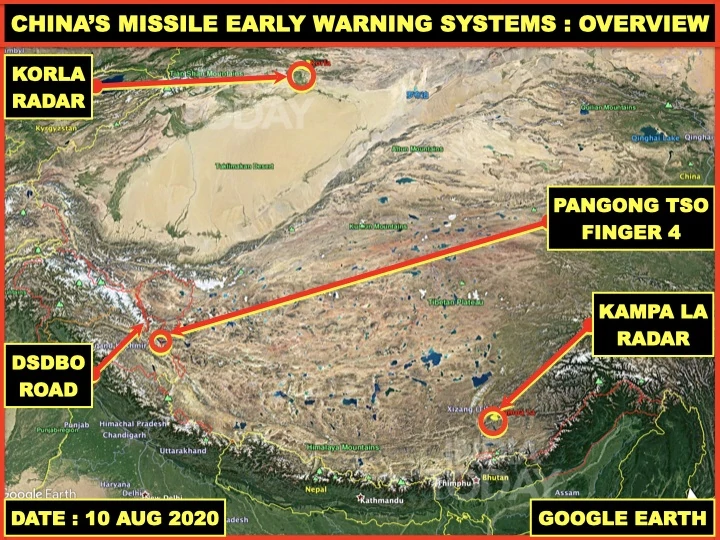
India Today’s OSINT desk takes a closer look through satellite imagery at China’s major missile warning systems deployed against India.
LPAR at Korla
China’s research work on Large Phased Array Radars (LPARs) began in late 1970s. The Nanjing Research Institute of Electronics Technology located was China’s premier organisation for large phased array radar development.
The first LPAR of China under Project 7010 was constructed in 1986 at Xuanhua, located 130km west of Beijing. The obvious task was to provide Ballistic Missile Early Warning or BMEW of the Russian strategic forces to Chinese Air Force.
The first LPAR on a rotatable turn table was constructed in 2004 at Korla, Bayingol, in central Xinjiang and not in Qinghai as many Indian media reports suggest.
Korla radar base is located 980km from Karakoram Pass and is 3,800km from India’s southern tip.
Satellite images show that the radar with a 16m wide hexagonal array has been used extensively during China’s trials of anti-satellite (ASAT) weapons and hypersonic glide weapons.
The quoted coverage of this radar is 4,000km of range and ±60° from direction of fire. Thus, it would cover more areas than entire India since swath of complete India East to West is less than 100° from the location of the LPAR.
Such radars can detect and track targets as small as 5cm in size at a much longer distance than quoted. It would certainly be able to detect, identify most missiles launched from India and engage them with appropriate weapons systems designated and integrated into the air defence plans.
Kampa La Radar Station
The radar station talked about in many Chinese media documentaries is a well-known radar site above the Kampa La or Kampa pass overlooking the Yamdrok Lake.
It is located at a height of 5,150m providing a clear view of the Himalayas. Kampa La radar station is 190km from India’s borders and 2,700km from India’s southern tip.
Kampa La radar station as seen in satellite images is equipped with radars like P-35 Bar Lock, YLC-2A and YLC-4 along with satcom and an earth station.
China claims that the Kampa La radar station is fully automated since 2008.
Recent training exercises indicate the People’s Liberation Army Air Force (PLAAF) with automated machines and weapons along with human machine integration.
This clearly indicates that Kampa La radar station in conjunction with artificially intelligentized weapons systems will autonomously be able to detect, identify, track, engage and finally destroy any target that presents itself within the station’s range.
China’s efforts to counter Indian missiles such as Agni-5 or Prithvi may be quite strong. However, that does not alter Indian capabilities.
India’s Strategic Forces Command needs to take into account these strategic assets of China to overcome their ballistic missile defence and hit the desired targets with precision.


